http://bit.ly/xcsoar
![]()
Manual em Português
(PDF, XCSoar-manual-traduzido-Brasil-1)
Passo 1
Faça download e instale a última versão
http://www.xcsoar.com
Passo 2
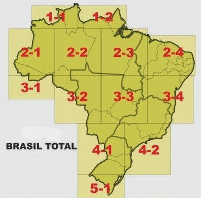
Faça download e instale o mapa. Selecione a região de interesse.
http://www.ridimuim.com.br/p/xcsoar.html
Passo 3
Encontre o arquivo do Espaço Aéreo do Brasil na página:
1) http://www.riowings.com.br/Equip_XCSoar.html (2012)
2) http://www.paramotorpr.com.br/espaco-aereo-brasileiro/ (2016)


Live Tracking
No próprio XCSoar tem a opção de fazer o Live Tracking. O voo pode ser acompanhado ao vivo por todos!
PASSO 1. Vamos precisar de um KEY para configurar o XCSoar.
- Acesse o URL: https://skylines.aero/
- Faça seu cadastro. É sem custo!
- Uma vez logado, vá em configurações
Configurações > Live Tracking - Lá aparece o KEY em um quadro com fundo azul.
- Copie esse KEY
- Saia do Skyline
PASSO 2. No XCSoar do seu celular
- XCSoar no modo FLY
- Acessa o menu (movimento do dedo de cima para baixo e termina em cima)
- CONFIG > SISTEMA > CONFIG > RASTRO
- A opção do SKYLINES vai está desligada. Clica no desligado, vai aparecer as opções. Clica no ligado e depois no selecionar (Para salvar)
- Depois,Tem uma opção na sexta linha KEY: digita o KEY!
- Clica em fechar (Para sair das configurações)
- Fecha o XCSoar.
- Abra o XCSoar e verifique o Live Tracking em: https://skylines.aero/tracking.
- OBS.: Caso não queira fazer o Live Tracking é só desligar a função. O KEY estará salvo e na próxima vez que ligar estará funcionando.
Complemente as informações com este site:
http://www.connectfly.com.br/index.php/language/pt/download/
MAIS DETALHES DE CONFIGURAÇÃO
Após seguir os passos acima, veja este Guia XCSoar para outros detalhes de configuração.
Adicionais
- http://voolivre.org/forum/10-xcsoar/ – Espaço destinado a dúvidas e problemas com o XCSoar, bem como tutoriais e dicas de uso e configuração.
- http://xcsoar-mapgen.sigkill.ch/ – Mapa customizado
- http://www.dpi.inpe.br/calcula
- Evento – http://youtu.be/gjLRRmb7Vr4
-
Waypoints – http://download.xcsoar.org/waypoints/Brazil.cup
name,code,country,lat,lon,elev,style,rwdir,rwlen,freq,desc
“AMELAND NETHERLN”,AMELA,NL,5327.100N,00540.633E,3.0m,2,90,800.0m,”118.350″,”AIRPORT”
“AMERSFOORT A28 A”,AMERSF,NL,5209.516N,00525.133E,20.0m,1,,,,”A28 AB007″
“AMSTERDAM”,AMSTE,NL,5218.483N,00445.850E,-2.0m,2,60,3490.0m,”118.100″,”AIRPORT”
Each line represents one waypoint with these fields, separated by commas. Here is an example: “Lesce-Bled”,”LESCE”,SI,4621.666N,01410.332E,505.0m,2,130,1140.0m,”123.50″,”Home airfield”
1. Name
This is the long name for the waypoint. It is supposed to be ebraced in double quotes to allow any characters, including a comma in between. This field must not be empty.
2. Code
Also known as short name for a waypoint. Many GPS devicees cannot store long waypoint names, so this field will store a short name to be used in various GPS types. It is advisable to put it in double quotes.
3. Country
IANA Top level domain standard is used for the country codes. A complete list is available at http://www.iana.org/cctld/cctld-whois.htm
4. Latitude
It is a decimal number where 1-2 characters are degrees,
3-4 characters are minutes,
5 decimal point,
6-8 characters are decimal minutes.
The ellipsoid used is WGS-19845. Longitude
It is a decimal number where
1-3 characters are degrees,
4-5 characters are minutes,
6 decimal point,
7-9 characters are decimal minutes.
The ellipsoid used is WGS-19846. Elevation
It is a string with a number with unit attached. Unit can be either “m” for meters or “ft” for feet.
Decimal separator must be a point.7. Waypoint style
It is a digit representing these values:
1 – Normal
2 – AirfieldGrass
3 – Outlanding
4 – GliderSite
5 – AirfieldSolid
6 – MtPass
7 – MtTop
8 – Sender
9 – Vor
10 – Ndb
11 – CoolTower
12 – Dam
13 – Tunnel
14 – Bridge
15 – PowerPlant
16 – Castle
17 – Intersection8. Runway direction
It is a string in degrees representing heading of the runway.
Only used with Waypoint style types 2, 3, 4 and 59. Runway length
It is a string for number with unit representing length of the runway.
Only used with Waypoint style types 2, 3, 4 and 5 unit can be either
“m” for meters
“nm” for nautical miles
“ml” for statute miles
Decimal separator must be a point.10. Airport Frequency
It is a string representing the frequency of the airport. Decimal separator must be a point. It can also be embraced in double quotes.
11. Description
It is a string field with no limitation in length where anything can be stored in. It should be embraced with double quotes.
XCSoar no Campeonato Brasileiro de Asa Delta 2013 from Henrique Frasson on Vimeo.